
| Invention Name | Groma, also known as the Roman surveyor’s cross |
|---|---|
| Short Definition | A surveying instrument that used suspended plumb lines to establish straight alignments and right angles. |
| Approximate Date or Period | Related forms existed by the 3rd–1st centuries BCE; the Roman form is well documented in the late Republic and early Empire. Approximate |
| Evidence Status | Based on surviving evidence Physical finds, carved images, Roman surveying texts, and later reconstructions |
| Geography | The Mediterranean world, especially Roman Italy and Roman provinces; related evidence survives from Egypt |
| Inventor or Source Culture | Unknown; a collective development linked with Mediterranean and Roman surveying traditions Attribution varies |
| Category | Measurement, surveying, civil engineering, land administration, and urban planning |
| Main Problem Solved | Creating repeatable straight lines, perpendicular lines, rectangular plots, streets, boundaries, and building alignments |
| How It Worked | A surveyor sighted through two opposite plumb lines; the second pair marked a direction at 90 degrees to the first |
| Technical Principle | Gravity kept suspended cords vertical, while the cross placed the sighting pairs at fixed right angles |
| Main Materials | Wooden staff and cross, metal fittings, cords, and stone or metal plumb bobs; materials varied by place and period |
| Supporting Equipment | Ranging poles, stakes, measuring rods, boundary markers, cords, and written survey records |
| First Use Areas | Land division, road alignment, town planning, military camp layout, agricultural boundaries, and construction setting-out |
| Main Users | Agrimensores, mensores, land administrators, military surveyors, engineers, and their assistants |
| Development Path | Ropes, stakes, and sighting methods → cross-and-plumb instruments → Roman groma → surveyor’s cross and optical square |
| Predecessors | Rope geometry, alignment stakes, plumb lines, gnomons, Egyptian land-measuring practices, and Greek surveying instruments |
| Later Forms | Surveyor’s cross, optical square, cross-staff instruments, angle-measuring instruments, theodolites, and electronic total stations |
| Main Variations | Light suspended crosses, pole-mounted Roman forms, reconstructed offset-arm forms, and later compact surveyor’s crosses |
| Impact Areas | Land management, construction, transport, agriculture, urban planning, legal records, taxation, and measurement |
| Surviving Evidence | A Roman example associated with Pompeii, a related object from Egypt, carved funerary images, surveying texts, and archaeological field systems |
| Main Uncertainty | The place of origin, date of first invention, exact form of some fittings, and relationship between Egyptian, Greek, Italian, and Roman versions |
| Related Inventions | Dioptra, gnomon, plumb line, measuring rod, chorobates, surveyor’s cross, optical square, and theodolite |
| Modern Descendants | Mechanical and optical instruments used to set perpendiculars, transfer alignments, measure angles, and record surveyed coordinates |
| Historical Importance |
|
What the Groma Was
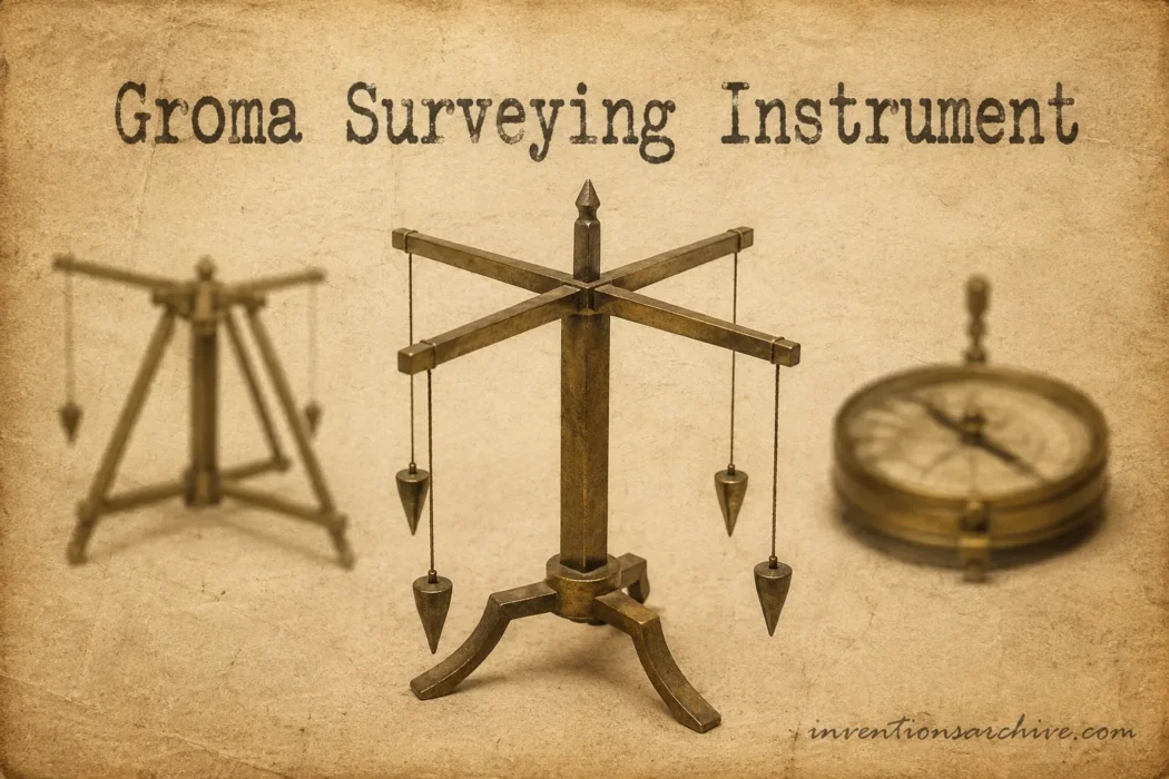
The groma was a field instrument for establishing direction. A typical reconstruction shows a vertical support carrying a horizontal cross. A cord and plumb bob hung from each of the cross’s four ends.
Opposite cords formed one sighting line. The other pair formed another line at a right angle. This arrangement allowed a surveyor to extend a baseline and then create a perpendicular line without calculating the angle each time.
The groma was therefore not a general-purpose measuring device. It did not independently provide every distance, gradient, elevation, or angle required by a survey. It performed one limited task well: transferring straight and perpendicular alignments onto the ground.
Other equipment completed the work. Assistants carried ranging poles. Measuring rods established distances. Stakes, stones, paths, ditches, walls, or planted boundaries could preserve the lines after the instrument was removed.
The Problem It Answered
Long before the groma, people could form a right angle with cords, marked ropes, pegs, and practical geometry. These methods were useful, but repeating an alignment across a broad area required care, labour, and a shared reference line.
Roman surveyors often worked on projects where a small angular error could spread across many plots or streets. They needed to extend one line, turn a dependable perpendicular, and repeat the arrangement at new stations.
The groma gave the surveying team a visible, portable reference for that work. Its value came from repeatability, not from mechanical complexity.
| Before the Groma | What Changed with the Groma |
|---|---|
| Right angles could be formed with ropes, pegs, and geometric layouts. | A fixed cross provided two perpendicular sighting directions in one portable instrument. |
| Extending a line depended heavily on repeated ground measurements. | Surveyors could sight along hanging cords toward distant ranging poles. |
| Turning a perpendicular often required a separate geometric construction. | The second pair of cords provided a ready-made 90-degree direction. |
| Irregular boundaries could be marked without a shared rectangular plan. | Large areas could be organised into related roads, plots, blocks, or field divisions. |
| Survey decisions might remain as temporary marks on the ground. | Aligned stakes and measurements could be transferred into boundaries, roads, plans, and administrative records. |
| Different teams might reproduce directions in different ways. | A recognised instrument supported more consistent professional practice. |
How the Instrument Worked
Main Parts
Museum reconstructions and historical studies commonly identify the following elements:
- Supporting staff: a vertical pole placed in or against the ground.
- Horizontal cross: two intersecting arms arranged at right angles.
- Plumb lines: cords suspended from the ends of the cross.
- Plumb bobs: weights that kept the cords vertical.
- Rotating or offset fitting: a proposed arm or mounting that allowed the sighting centre to be positioned over a ground mark.
- Survey station: the point on the ground from which the lines were projected.
Museo Galileo describes a surveyor’s cross composed of a supporting rod, a rotating arm, and a wooden cross with iron fittings. Two pairs of plumb lines hung from the cross. Their projected directions were transferred to the ground with aligned stakes.[c]
The Sighting Principle
The surveyor looked past two opposite cords toward a ranging pole held by an assistant. When both cords and the pole appeared on the same visual line, the assistant’s position continued the selected direction.
The process could be repeated farther along the site. A second line was then formed by sighting through the other pair of cords. Because the cross arms were perpendicular, this second direction was intended to meet the first at 90 degrees.
The plumb lines did not measure the horizontal distance to the pole. They served as visual references. Distance had to be established with separate rods, cords, paces, or other measuring tools.
Why Gravity Mattered
Each cord hung downward under gravity. When the instrument was steady, the cords supplied narrow vertical references that could be aligned with a distant marker.
This simple principle also created a weakness. Wind could move the cords. Uneven ground could make positioning difficult. A damaged cross, unequal suspension points, or poor station placement could introduce error.
How Its Origin Is Traced
The groma did not appear in a landscape without earlier measurement knowledge. Mesopotamian records show geometric work with land parcels. Egyptian surveyors restored boundaries and planned construction. Greek mathematicians developed geometric reasoning and used instruments such as the dioptra.
These traditions show that the practical problems addressed by the groma were already old. They do not prove that one civilisation handed a finished instrument directly to another.
Some researchers have proposed Greek influence. Other interpretations give more weight to Egyptian surveying or to an Italian and Etruscan setting. The evidence does not settle the route.
The safest historical description is that the Roman groma belonged to a shared Mediterranean history of practical geometry. Roman surveyors adopted, standardised, documented, and widely used a cross-and-plumb method suited to their administrative and construction needs.
Why There Is No Named Inventor
The groma is unlike an invention documented by a dated patent. Its parts could be made by ordinary craftspeople, and its principle could develop gradually through field practice.
No surviving Roman source provides a credible statement that one named person invented it. Treating it as the work of a single Roman engineer would create certainty that the evidence does not provide.
The instrument is better understood as a collective technical development. Surveyors, carpenters, metalworkers, administrators, and military specialists may all have contributed to the forms that entered Roman practice.
Surviving Objects and Records
Knowledge of the groma comes from several kinds of evidence. Each type answers different questions.
Physical Remains
The best-known Roman find is associated with Pompeii. Its preservation gave historians a physical basis for reconstructing the cross, fittings, suspension system, and accompanying survey equipment.
The Egyptian object held by the Science Museum Group uses organic cross pieces and stone plumb bobs. The museum identifies it as a predecessor or early related form, while also recording that missing portions were reconstructed. It shows that cross-and-plumb surveying was not confined to one material or one Roman workshop.
Carved and Pictorial Evidence
Funerary monuments sometimes showed the tools connected with a person’s occupation. Such images help identify the groma as a recognised mark of the professional surveyor.
The official Pompeii archaeological site records a marble tombstone commemorating Popidius Nicostratus, an agrimensor. A groma, stakes, and a plumb line were carved among his working tools.[e]
This image does not provide a construction drawing. It does show that the instrument was closely associated with land surveying and professional identity.
Written Evidence
Roman surveying writings discuss boundaries, land categories, measurements, disputes, layouts, and survey procedures. Much of this material survives through later manuscript collections commonly called the Corpus Agrimensorum Romanorum.
The texts were copied, edited, and reorganised over centuries. They preserve valuable professional knowledge, but they do not form a single contemporary instruction manual. Some passages describe practices from different periods or regions.
Landscape Evidence
Archaeologists also examine surviving roads, field boundaries, drainage lines, property divisions, and urban grids. Regular alignments may preserve part of an earlier Roman survey.
A rectangular landscape alone does not prove that a groma was used at every point. The pattern must be assessed with dating evidence, excavation, inscriptions, maps, boundary markers, and local history.
Roman Surveying in Practice
The groma was used within a team rather than as an isolated object. The surveyor observed the cords and directed assistants. Other workers moved poles, placed stakes, measured distances, cleared lines of sight, and marked the ground.
Roman surveying developed into a recognised body of skilled work. New York University’s Institute for the Study of the Ancient World notes that Roman surveyors served land taxation, agricultural division, settlement planning, engineering, military support, cadastral recording, and boundary arbitration.[d]
Land Division
One of the groma’s best-known uses was the division of land into related rectangular units. Roman writers used terms such as limitatio and centuriatio for organised systems of boundaries and plots.
A principal baseline could be laid out first. Perpendicular and parallel lines were then extended at measured intervals. The resulting divisions could be marked by roads, paths, ditches, walls, stones, vegetation, or other visible boundaries.
The groma established the directions. The size of each parcel depended on the measuring system and administrative plan, not on the instrument itself.
Towns and Streets
Surveyors could use perpendicular axes to organise streets, public areas, building plots, drainage lines, and property blocks in a new settlement.
The terms cardo and decumanus are often used for major crossing axes. They are frequently simplified as fixed north–south and east–west streets. Real layouts could respond to terrain, coastlines, existing roads, water management, and local planning decisions.
The groma did not decide where north was or select the best route through the landscape. Once a baseline had been chosen, it helped the team extend that line and form perpendiculars from it.
Military Camps
Temporary and permanent camps required organised roads, entrances, work areas, and building spaces. A cross-based survey gave military specialists a practical way to transfer a chosen layout onto open ground.
Military use is often emphasised because camps could follow regular plans. The groma was not only a military instrument. Civilian land division, settlement planning, property administration, and road work were equally important parts of its history.
Roads and Construction
Road builders needed to preserve alignments between distant points. Builders also needed perpendicular offsets for walls, foundations, streets, and plots.
The groma could support this setting-out work on fairly open and manageable terrain. It was less suited to determining gradients or working across severe changes in elevation. Levelling and complex angular work required other instruments and methods.
Records and Boundary Disputes
Survey work did not end when stakes were placed. Measurements and parcel information could be entered into maps, registers, inscriptions, or administrative records.
These records supported taxation, land allocation, ownership claims, public access routes, water rights, and the settlement of boundary disputes. The groma therefore belonged to a wider system connecting field measurement with legal and administrative evidence.
Materials and Technical Principle
No single surviving specimen defines every groma ever used. Organic materials decay, and metal pieces can be separated from their original wooden parts. Reconstructions must combine physical fragments with images and texts.
The Cross
The cross established the fixed relationship between the two sighting directions. Wood kept the structure portable. Metal fittings could reinforce joints, suspension points, or rotating components.
A poorly formed cross would transfer its error into every perpendicular line. The shape and rigidity of the cross mattered more than elaborate decoration.
The Cords and Bobs
The cords had to hang freely and remain visible. Plumb bobs supplied enough weight to tension them. Stone, metal, or other dense materials could serve this purpose.
Different bob shapes or weights may have helped surveyors distinguish one sighting pair from the other. Some interpretations also suggest that the instrument could be reversed or checked to detect misalignment.
The Support and Offset
A survey point had to correspond with the centre of the cross. Yet placing a vertical staff directly under that centre could obstruct the surveyor’s view.
Many reconstructions therefore use an offset or rotating arm between the staff and the cross. The exact arrangement remains debated because surviving fragments and carved images do not answer every mechanical question.
Development Path
| Stage | Form | What Changed |
|---|---|---|
| Earlier Method | Ropes, stakes, plumb lines, sighting poles, and geometric ground layouts | Surveyors could establish lines and angles, but repeated field construction took time and careful measurement. |
| Early Cross Form | Suspended cross with opposite plumb-line pairs | Two perpendicular sighting directions were combined in one simple device. |
| Roman Groma | Cross and plumb lines mounted on a field support | The instrument could be positioned over a station and used with assistants, poles, and measuring rods. |
| Improved Compact Form | Surveyor’s cross | A more compact device provided fixed right-angle sighting lines without long hanging cords. |
| Optical Form | Optical square and related prism instruments | Mirrors or prisms allowed perpendicular offsets to be observed with less interference from wind. |
| Precision Angle Instrument | Theodolite | Surveyors could measure many horizontal and vertical angles rather than only transfer a fixed right angle. |
| Modern Descendant | Electronic total station | Angle measurement, distance measurement, calculation, and digital data recording were combined in one system. |
This sequence is a history of related functions rather than a proven line in which each instrument was directly copied from the one before it. The surveyor’s cross and optical square are closer functional successors. The theodolite and total station belong to a broader development of angle measurement and coordinate surveying.
Main Forms and Variations
Ancient sources do not provide a formal catalogue of groma models. Variations are reconstructed from surviving objects, archaeological fragments, carved images, and later instruments that performed similar work.
| Form | Typical Features | Evidence and Use |
|---|---|---|
| Suspended Cross Form | Light cross, four cords, and stone plumb bobs | Known through the Egyptian object in the Science Museum collection; missing parts were reconstructed. |
| Roman Pole-Mounted Groma | Vertical support, cross, fittings, cords, and weighted bobs | Associated with Roman land surveying and reconstructed from Pompeian evidence. |
| Offset-Arm Reconstruction | Cross positioned away from the vertical staff by a rotating arm | Explains how the survey centre and sighting lines may have remained clear, but the exact arrangement is debated. |
| Central-Plummet Version | Additional cord marking the point beneath the cross centre | Useful for positioning the instrument; it may have been removable during sighting. |
| Surveyor’s Cross | Compact head with fixed sighting slots or vanes | Later instrument for establishing straight lines and right-angle offsets. |
| Optical Square | Mirrors or prisms forming a 90-degree sight | Later optical solution for perpendicular offsets, less dependent on exposed hanging cords. |
What Changed Because of It
The groma did not create Roman geometry or invent rectangular planning. Its contribution was practical. It helped survey teams reproduce geometric decisions over real ground.
Repeatable Field Layout
A planned line on a drawing has little value until it can be transferred onto soil, rock, or an active building site. The groma connected a geometric plan with visible field markers.
Surveyors could preserve a chosen direction across successive stations. Perpendiculars could be extended from the same baseline. This supported related roads, walls, plots, and drainage lines rather than isolated measurements.
Coordination Between Workers
The instrument gave the surveyor and assistants a shared visual procedure. One person observed the cords. Another carried the pole. Others measured, marked, checked, and recorded.
This division of labour made surveying a coordinated technical activity. Accuracy depended on the full team, not only on the person standing beside the groma.
Land as Recorded Space
Once boundaries were measured and marked, they could be represented in registers or maps. Parcels could be named, allocated, taxed, transferred, or discussed in legal disputes.
The instrument’s wider effect came from this link between physical alignment and recorded land. A line first sighted through two cords might later become a road edge, property boundary, field division, or entry in an official record.
Later Surveying Needs
The groma also revealed the limits of fixed-angle instruments. Surveyors working with slopes, distant heights, irregular angles, or difficult terrain needed more capable equipment.
Later instruments added graduated circles, sighting vanes, telescopes, levels, mirrors, prisms, distance measurement, and electronic recording. The task grew from transferring right angles to calculating three-dimensional positions.
What the Groma Could Not Do
- It did not measure distance by itself. Rods, cords, or other measures were required.
- It did not automatically locate north. The surveyor first needed an orientation or chosen baseline.
- It did not read every possible angle. Its cross was designed mainly for straight and perpendicular directions.
- It was not a levelling instrument. Gradients and elevation differences required other methods.
- It was vulnerable to wind. Moving cords made precise sighting difficult.
- It did not create a map automatically. Observations had to be measured, recorded, calculated, and drawn.
- It did not remove human error. Poor station placement, misaligned parts, unclear sighting, or inaccurate distance measurement could affect the result.
These limits do not make the groma ineffective. They define the job for which it was suited. It was a specialised alignment tool, not an ancient version of every modern survey instrument.
Common Misunderstandings
“The Romans Invented Surveying”
Surveying existed in Mesopotamia, Egypt, Greece, and other societies before Roman expansion. Roman specialists developed a large professional and administrative use of earlier geometric knowledge.
“One Roman Engineer Invented the Groma”
No reliable surviving record names a single inventor. The instrument probably emerged through repeated practical development across more than one region and generation.
“The Oldest Surviving Object Must Be the First Groma”
The oldest object known today is only the earliest surviving or recognised evidence. Earlier instruments may have decayed, been recycled, remain undiscovered, or never entered the archaeological record.
“The Groma Measured Land Area Directly”
The instrument established lines and right angles. Area was derived from measured lengths, plot geometry, calculations, and records produced by the survey team.
“Every Roman Town Followed the Same Compass Grid”
Regular crossing axes were common in planned settlements, yet orientation could reflect terrain, existing routes, coastlines, drainage, and local needs. The groma transferred the chosen geometry; it did not impose one universal direction.
“Modern Reconstructions Are Exact Copies”
Reconstructed gromae combine archaeological parts, ancient images, written descriptions, and mechanical interpretation. Details such as the mounting arm and central plummet remain open to discussion.
Related Inventions
- Plumb Line: supplied the vertical reference used by each hanging cord.
- Gnomon: used shadows to establish direction, time, or astronomical orientation.
- Dioptra: a Greek and Roman sighting instrument associated with horizontal and vertical angular work.
- Measuring Rod: established distances that the groma itself could not measure.
- Chorobates: supported levelling work, especially where gradients mattered.
- Surveyor’s Cross: a later compact instrument for straight lines and perpendicular offsets.
- Optical Square: used optical components to observe a fixed right angle.
- Theodolite: measured a wider range of horizontal and vertical angles with graduated scales and optical sights.
Frequently Asked Questions
Who invented the groma?
No named inventor can be confirmed. The groma developed within older Mediterranean surveying traditions and became closely associated with Roman professional land surveyors.
What did a groma measure?
It mainly established straight sighting lines and perpendicular directions. Separate rods, cords, or other measures were used for distance, while area was calculated from the surveyed dimensions.
How accurate was the Roman groma?
It could produce useful straight and right-angle alignments when the cross was correctly formed, the station was stable, and the cords remained still. Wind, uneven terrain, poor visibility, and setup errors reduced its reliability.
Was the groma used only by the Roman army?
No. Military surveyors used it for camps and related construction, but civilian surveyors also used it for agricultural land, roads, settlements, property boundaries, and administrative surveys.
Did the groma always align towns with the compass points?
No. A surveyor could use astronomical or directional observations when choosing a baseline, but a town or field grid could also follow terrain, an existing road, drainage needs, or another local reference.
How was the groma different from the dioptra?
The groma was suited to extending straight lines and fixed perpendiculars. The dioptra was a more elaborate sighting instrument associated with measuring varied horizontal or vertical angles, heights, and other geometric relationships.
Does an original groma survive?
Physical parts and related objects survive, including evidence associated with Pompeii and an Egyptian cross-and-plumb object in the Science Museum Group collection. Some wooden or missing elements have been reconstructed, so not every displayed instrument is wholly ancient.
Sources and Verification
- [a] The Groma — Surveying Instruments of Greece and Rome — Used to verify the instrument’s main functions, debated origin, and association with roads, towns, camps, and rectangular land divisions. (Reliable because it is a specialist academic chapter published by Cambridge University Press.)
- [b] Groma, Roughly Made — Science Museum Group Collection — Used to verify the Egyptian object’s date, excavation history, materials, reconstructed parts, operating principle, limitations, and later functional successors. (Reliable because it is an official museum collection record with object and provenance data.)
- [c] 2.4 Groma (Surveyor’s Cross) — Museo Galileo — Used to verify the supporting rod, rotating arm, wooden cross, iron fittings, paired plumb lines, and use of aligned stakes. (Reliable because it is a topic-specific institutional history-of-science resource from Museo Galileo.)
- [d] Measuring the World — Institute for the Study of the Ancient World — Used to verify the earlier Mesopotamian, Egyptian, and Greek surveying context and the Roman use of surveyors in taxation, settlement planning, engineering, records, and boundary decisions. (Reliable because it is a subject-specific educational resource published by New York University.)
- [e] Antiquarium, Room I — Pompeii Sites — Used to verify the tombstone of Popidius Nicostratus and its carved depiction of a groma, stakes, and plumb line as surveyor’s tools. (Reliable because it is an official archaeological collection page from the Archaeological Park of Pompeii.)